 |
Satellite Information
|
Current Satellite Data
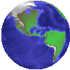
Current GOES Satellite Images
Current Geostationary Weather Satellite Images
Current Geostationary Weather Satellite Images
Purpose of Satellite Data
The use of satellites to make observations of the earth goes back to the
50's and 60's. With the first downward looking images of the earth
it was very easy to identify the location of storm systems and track their
movement. This capability did not have a large impact in weather
forecasting since we already had a network of observing stations established.
However, the greatest benefit came in the observation of weather systems
developing over the oceans where it is difficult to establish a network
of observing stations.
Satellites have become much more sophistocated over the years and are
much more than cameras in the sky. They are now able to measure physical
parameters of the earth's atmosphere and the earth's surface. This
includes such things as surface temperature, land productivity, and precipitation.
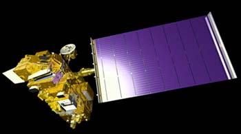
 TERRA (EOS-AM1)
TERRA is the first of a series of satellites that belong to the Earth Observing
System (EOS). It was launched December 18, 1999 and will begin regular
transmission of data in late April 2000.
Homepage for TERRA
Image Gallery of
TERRA and its Sensors
 Description of Terra
TERRA consists of 5 sensors which will be used to study aerosols, global
cloudiness, heat transfer in the atmosphere, changes in global land surface,
and oceanic effects on climate. The 5 sensors are listed below with
a short summary of their purpose. TERRA orbits at an altitude of
705 km and will remain in operation for 5 years.
ASTER (Advanced Spaceborne
Thermal Emission and Reflection Radiometer) - Purpose is to "obtain
high spatial resolution global, regional, and local images of the Earth
in 14 spectral bands."
Technical
Specification for ASTER
Description
of ASTER data products
CERES (Clouds
and the Earth's Radiant Energy System) - Purpose is to measure changes
in the radiative energy balance due to long-term climate changes, diurnal
and seasonal cycles, and cloud forcing.
Description
of CERES data products
Online Documentation
for CERES
MISR (Multi-angle Imaging SpectroRadiometer)
- Purpose is to study "the ecology and climate of Earth through the acquisition
of global multiangle imagery on the daylit side of Earth.
Technical
Specification for MISR
Publication
Listing related to MISR
MODIS (Moderate-resolution
Imaging Spectroradiometer) - Purpose is to study the "global dynamics
and processes occuring on the land, in the ocean, and in the lower atmosphere."
Technical
Specification for MODIS
Publication
Listing related to MODIS
Description
of MODIS data products
MOPITT
(Measurements of Pollution in the Troposphere) - Purpose is to "measure
carbon monoxide and methane in the troposphere over the entire globe."
Online
Documentation for MOPITT
Data Sources and Resources
Goddard DAAC - This location provides
the front end for accessing data from MODIS as well as other satellite
sensors.
NCSA HDF - Data from MODIS
will be distributed in the HDF format. HDF was developed at the University
of Illinois and this site contains information and programs which allow
you to access HDF data files.
Remote
Sensing Tutorial - This document provides background on remote sensing
and introduces you to terminology and techniques of applying satellite
data to observations of physical parameters.